Severe weather to hinder the Plains and Midwest Saturday

Widespread severe weather is expected across the Plains and Midwest Saturday. Strong damaging winds, giant hail and tornadoes are likely.
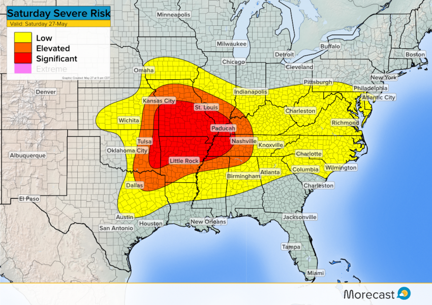
*Update: May 27, 2017 at 9 am CDT*
Discussion:
An upper-level disturbance with a surface front and dry-line will trigger a significant threat for severe weather Saturday. Also there is a very moist and unstable air mass which could cause these storms to be long lasting and turn severe very quickly.
A line of storms will start to develop over the Plains in the afternoon and will quickly move to the southeast in the evening. The low level jet will keep storms going strong into the night. Multiple hazards are possible in the ‘significant’ area with hail potential of 2″+, strong wind gusts and tornadoes. The primary threats across the ‘elevated’ areas are wind and hail but there is a potential for an isolated tornado or two.
Severe Risk Map:
We’ll continue to issue updates as the event unfolds, just keep an eye on our Facebook and Twitter feeds. The new Morecast.com will also have the latest information! Photo Credit: NOAA Photo Library
