Lingering remnants of Cindy bring severe storms to the East Friday

Severe weather is expected across the East with the remains of Sandy helping to fuel the storms on Friday.
Severe Set up
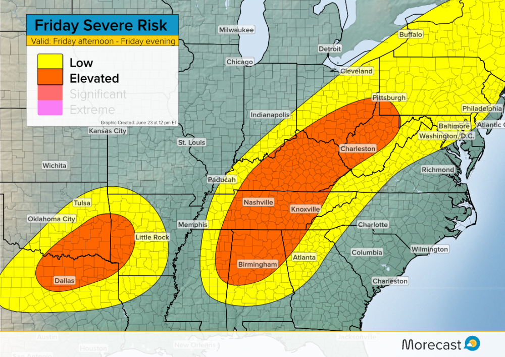
What is left of Cindy moved into the Tennessee Valley on Friday, bringing plenty of tropical moisture further north. With the combination of the moist air and a cold front, residents can expect strong storms and heavy rain. Further west in the Plains, an unstable air mass will be conducive for severe weather as well.
An elevated risk of severe storms exists from Ohio down into Mississippi, as well as a small portion of Arkansas, Oklahoma, and Texas. Several major cities are included in this area, such as Dallas, Nashville, and Birmingham. Further north, a much lower risk of severe storms exists for the Northeast.
Timing
Thunderstorms in the east will start off non-severe early on Friday. By mid-afternoon, a line of storms will strengthen, bringing strong damaging winds from Ohio to Mississippi. By the evening hours, the greatest threat shifts east towards the coastal states before conditions for severe storms begin to deteriorate.
In the Southern Plains, the day will start out mostly sunny, with storms developing in the late afternoon and continuing into the evening hours.
Impacts
The most severe storms will likely produce wind gusts in excess of 60 mph, especially for elevated risk areas. A slight chance of tornadoes exists for the Tennessee Valley with plenty of wind shear present to get a few tornadoes going. In addition to wind and isolated tornadoes, the moisture from Cindy will lead to flash flooding with many of these storms.
In the Southern Plains, wind will also be the primary threat with any of the storms. A slight chance exists for some hail to fall with the strongest storms.
Follow us on Twitter and Facebook for severe weather updates.
