Midwest Heat Wave Shifting East Next Weekend; West Cools Off

The Midwest has been baking through much of June, and the West has joined in over the past week with extensive heat advisories and warnings. Meanwhile, the Northeast has enjoyed very comfortable temperatures for early summer. The pattern looks to change later this week, however.

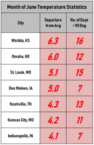 The graphic above show the departure from normal of average temperatures across the country for June, with select cities in the table at left. Much of middle portion of the country from the Rockies through the Plains to the Midwest is near or above plus five deg F. Temperatures have been near normal in the Northeast. However, the ridge responsible for the Midwest heat is expected to expand east.
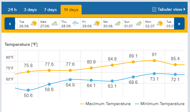
The forecast graph below for Burlington, Vermont shows a steady climb late this week into early next week. This is a good representative forecast for many locations in the Northeast. Temperatures will be well into the 80s, approaching 90 degrees, for most locations, even the big coastal cities.
The last forecast map below shows expected temperature trends across the nation in the 6-10 day time frame (this weekend into early next week). Near to below normal temperatures now confined to the Pacific Northwest will expand into the Rockies. The eastern two-thirds are very likely to see above normal temperatures, in some areas far above normal. The Plains will be in the transition zone, potentially seeing a temperature roller coaster. Lead photo courtesy Air Force Staff Sgt. Josie Walck.