Barry Briefly a Hurricane Near Landfall, Now Slowly Weakening over Inland Louisiana
Hurricane Barry made landfall near Intracoastal City in south-central Louisiana around midday Saturday. Barry has continued to struggle with dry air intruding on the northern side. However, surface and reconnaissance plan data indicate the storm may have been producing hurricane-force conditions at landfall. As the storm moves further inland, heavy rain and flash flooding will become the predominant threat!
#Barry started the day not looking like a typical tropical cyclone.. now it does, ironically after moving inland pic.twitter.com/vde53o9FYv
— Stu Ostro (@StuOstro) July 13, 2019
Numerous reports of damaging winds and significant storm surge have been received from across southern Louisiana. Gusts of 40-70 mph (60-110 kph) have knocked down numerous trees and power lines, leading to thousands of power outages. A storm surge measured as high as 5-7 feet (2 m) has flooded coastal communities from the LA-MS state line to near the landfall point. Some levees protecting low-lying areas have been overtopped and damaged. Fortunately, as the center moves further inland, winds and surge flooding will continue to slowly subside, although localized flooding will still be likely around the astronomical high tide.
Terrebonne Parish in #Louisiana was hard-hit with storm surge inundation on Saturday. Here’s a few scenes from the area. #LAwx #Barry pic.twitter.com/a3Zrd8jThu
— WeatherNation (@WeatherNation) July 13, 2019
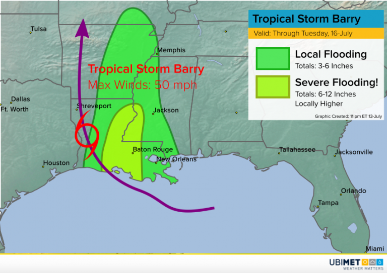
The heaviest rains so far have been falling to the south and east of the storm center. For much of the day, the heaviest rains were falling with a stationary band way east of the center, in Mobile, Alabama. Rainfall amounts up to 5-6 inches (125-150 mm) there lead to localized flooding. A new band of rain has set up over southeast Louisiana. This tropical moisture tap will be persistent through the next 24+ hours, eventually expanding further north into portions of Mississippi and Arkansas. Within this band, rainfall amounts of 3-6 inches (75-150 mm) will be common. Much heavier amounts of 6-12 inches (150-300 mm) or more are likely for central LA and southwest MS, where some serious flooding will occur.
