MONDAY MORNING UPDATE: Isaias Raking the Southeast Coast, Could Still Intensify!

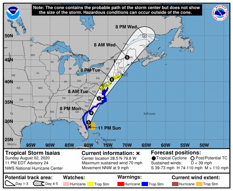
Tropical Storm Isaias has remained somewhat disorganized through Sunday. The eastern (offshore) half of the storm has remained dominant, sparing the Atlantic coast of Florida the heaviest winds and rains. However, there are signs that Isaias could regain its hurricane status as it turns toward the Carolinas on Monday. Destructive winds and flooding are still major threats along the Carolina coast.
One notable trend w/ #Isaias today vs prior days is that this convective burst that initially went up this am didn’t immediately collapse & has been continuously bursting for ~12 hrs. This is a clue that #Isaias‘s environment is starting to become more conducive to strengthening pic.twitter.com/cG5v69G0iD
— Eric Webb (@webberweather) August 2, 2020
Radar and satellite imagery continues to show a lopsided tropical storm with the heaviest activity well to the east of Florida. Wind gusts over Florida have remained less than 50 mph (80 kph). Rainfall totals have generally been less than two inches (50 mm). Upper level shear is relaxing over the storm, however, and the latest satellite scans indicate that Isaias may be becoming more symmetrical. Isaias is expected to continue on a north-northwesterly path into Monday before it turns north and north-northeast. This path would keep it far enough east to minimize the disruptive influence that land usually has on a tropical cyclone. The storm will also be moving over very warm Gulf Stream waters. Model guidance is coming around to the idea that Isaias may gain strength before landfall in the Carolinas Monday night.
#Isaias is forecast to bring a swath of 3 inches or more of rain from South Carolina all the way to Maine. With that kind of rainfall, flash flooding is likely. Don’t bet your life on “I can make it…” #TurnAroundDontDrown pic.twitter.com/CO7J53bwsD
— National Weather Service (@NWS) August 2, 2020
Regardless of whether Isaias is a strong tropical storm or a weak hurricane, dangerous weather will threaten the coastal Carolinas within the next 24-36 hours. Landfall is likely to occur near the Carolina border. Near and east of the landfall point, watch for a destructive storm surge of up to 3-4 feet (1-1.2 m). Damaging winds locally gusting 70-90 mph (110-145 kph) will also occur. Tropical storm-force winds could impact areas as far north as southern New England by midweek as the storm accelerates. Flooding rainfall will encompass a much larger region as the storm merges with a large trough now over the Midwest. Very heavy rains will fall from the Appalachians through the Mid-Atlantic and Northeast (see tweet above).
