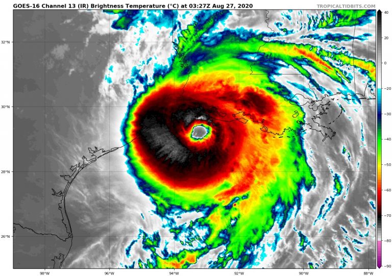
Dangerous Hurricane Laura Bearing Down On Louisiana!

An extremely dangerous Hurricane Laura is currently spinning off the coast of Louisiana, poised to make a destructive landfall along the southwest Louisiana coast early on Thursday morning. Laura, a formidable Category 4 storm is packing winds of 150 mph (241 kph), just 7 mph (11 kph) shy of Category 5 strength. Laura will be the strongest storm ever recorded to make landfall in southwestern Louisiana, and is the strongest hurricane of 2020 thus far. Already a record breaker even before landfall, Laura became the earliest “L” storm ever recorded in the Atlantic Basin, forming on August 20th, surpassing Tropical Storm Luis, which formed on August 29th, 1995.
Over 24 hours, Laura rapidly intensified from a Category 1 hurricane without an eye to a Category 4 with a well-defined eye. Here’s what that looked like on satellite imagery. https://t.co/xCwpD3KdrD pic.twitter.com/ZZaEB8qOJe
— CNN (@CNN) August 27, 2020
Laura is on track to bring catastrophic damage in the form of flooding rains, damaging winds, and life threatening storm surge. Storm surge is forecasted to reach up to 20 ft (6 m) in some locations, and may penetrate up to 40 miles (64 km) inland from the coast. The National Weather Service has deemed this an “Unsurvivable” surge.The city of Lake Charles, Louisiana is expecting a particularly hard blow as it is low-lying, and surrounded by several waterways that connect to the Gulf of Mexico.
Just before midnight in Sulphur #Louisiana. Starting to rip. #Hurricane #LAURA pic.twitter.com/vi9b0hCdXX
— Josh Morgerman (@iCyclone) August 27, 2020
Widespread power outages are almost certain as wind gusts will be well in excess of 100 mph (161 kph). Laura is likely to retain hurricane status even by the time she reaches Shreveport, Louisiana, which is situated in the northern part of the state. This would be anomalous in itself. Excessive rainfall amounts of up to 18 inches (457 mm) are possible, with rainfall rates between 5-7 inches (127-178 mm) per hour at times. Tornadoes are also possible in locations to the east of Laura’s track.
Here are the Key Messages for extremely dangerous Hurricane #Laura for Thu pm. An unsurvivable storm surge with large and destructive waves is coming soon for Sea Rim State Park TX to Intracoastal City, LA, including Calcasieu and Sabine Lakes & could penetrate 40 miles inland. pic.twitter.com/k6Ds0jAjni
— National Hurricane Center (@NHC_Atlantic) August 27, 2020
A trail of destruction has already been left by Laura, as the storm traversed the northern Caribbean Islands over the weekend. Most of the damage was due to potent rainfall amounts, which totalled nearly a foot (3.6 m) in portions of the region. The heavy rain triggered flash-flooding, especially in the Dominican Republic. Besides Louisiana, other states including Texas and Arkansas are expected to feel the wrath of Laura within the next day.
❗Breaking: Oil rigs evacuated ahead of soon to be Category 5 HurricaneLaura. Potential environmental nightmare looming.pic.twitter.com/AAuchx5CoT
— -🇮🇳కరణ్💭💤 (@Hidderkaran) August 27, 2020
