Meandering Eta Dumps Torrential Rain Across South Florida; Future Path Uncertain

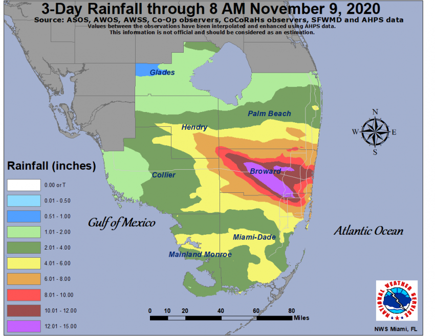
Tropical Storm Eta, which struck Central America as a Category Four hurricane last week causing tremendous devastation, clipped southern Florida Sunday night. The most widespread hazard has been torrential rainfall, in some areas well in excess of a foot (305 mm) (see map below). Significant flash flooding has been reported, leading to stalled vehicles requiring water rescues. Some of the stronger bands have also produce damaging wind gusts of 50-65 mph (80-105 kph). The Florida Keys and the Miami metro area have been particularly hard hit (see tweet below). However, as Eta has pulled away from the region, impacts have subsided somewhat.
Another rain band coming through #Brickell Another smaller car stalled. 😳 @wsvn pic.twitter.com/RoJCtj10wL
— Lorena Estrada (@EstradaLorena) November 9, 2020
Eta is the 28th storm of the Atlantic hurricane season, tying a record for the busiest season on record. Eta has already been responsible for approximately 250 deaths, including 150 in Guatemala. After bashing Central America, Eta has gone through cycles of weakening and strengthening over land and water. The storm moved north and made a second landfall over Cuba on Saturday. It then turned west and moved slowly across the Florida Keys on Sunday into Sunday night. The frequent proximity to land and lateness of the season have hampered Eta’s ability to gain strength. The storm has ingested a significant amount of dry air, toxic to a healthy tropical cyclone. Current satellite imagery of the storm over the southeast Gulf of Mexico (see tweet below) shows a storm relatively devoid of strong thunderstorm activity in its core. Eta will have a hard time intensifying as long as this dry air is being incorporated into the structure.
Why #Eta is struggling in one (water vapor) satellite loop:
Dry air (in dark orange, red) dominates the western and central Gulf of Mexico. (Images: NOAA, CIRA/RAMMB) pic.twitter.com/9vO5nzVAzF
— Jonathan Erdman (@wxjerdman) November 9, 2020
Given the weak steering winds and uncertainty about intensity, it’s no wonder that model guidance shows a wide variety of potential paths for the system. Some take it towards Tampa Bay, others towards Louisiana or even further west. Fortunately, almost none of the models show a significant amount of strengthening. Nevertheless, residents all along the US Gulf Coast should keep a close eye on Eta this week. Lead photo courtesy flickr user Carvalho.
