Eta Makes Final Landfall In Florida!

After making landfalls in Nicaragua, Cuba, and The Florida Keys over the last week, Eta made it’s fourth and final landfall early on Thursday morning as a tropical storm near Cedar Key, Florida. With winds of 50 mph (80 kph) this was the weakest of the 4 landfalls, but nonetheless, Eta still managed to wreak havoc as it crossed through Central Florida. After being missed by nearly every storm this season, Eta is the first storm of 2020 to make landfall in the state.
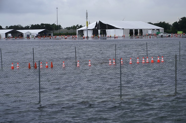
Tropical storm Eta brought rounds of torrential rain to parts of Florida Wednesday evening, resulting in severe flooding.
Eta made landfall as a tropical storm near Cedar Key, Florida, and is now fueling relentless heavy rain up the coast. https://t.co/Kw1Gg2iNei pic.twitter.com/3MsDAQPIZ5
— ABC News (@ABC) November 12, 2020
Although Eta’s effects in Florida were nowhere near the level of devastation seen in Central America, they still were quite destructive. These effects include flooding rains, damaging winds, and storm surge. With a storm surge of up to 3 feet (0.91 meters), many areas in and around Tampa experienced surge flooding as the water from Tampa Bay flowed in. While the surge flooding inundated many neighborhoods, it was not as bad as anticipated. Winds were also not as high as feared, but were still able to tear off a few roofs from mobile homes, and take down some trees.
Your reminder to never underestimate a tropical storm…
Footage from #Eta in Florida ⬇️ pic.twitter.com/1b3M7LcifW
— The Weather Channel (@weatherchannel) November 12, 2020
While not the staggering rainfall totals seen in South Florida from Eta, where estimates are between 20-25 inches (508-635 mm), the 2-6 inches (51-152 mm) that fell over Central Florida were enough to cause problems. The combination of flooding from rainfall and surge led to numerous water rescues, including 33 people in Pinellas County alone. A man in Bradenton Beach was electrocuted, and died, as he touched an appliance in his flooded home.
Areas around Tampa Bay, Florida saw their fair, or unfair, share of flooding Wednesday night as Tropical Storm Eta unleashed heavy rain and strong winds in the area. https://t.co/eOI3d7qye1
— CBS 42 (@CBS_42) November 12, 2020
Florida was not the only state to see effects from Eta. Moisture drawn in from Eta combined with a cold front to produce devastating flooding in North Carolina from Wednesday into Thursday. 5 deaths are attributed to Eta across that state as rainfall, up to 10 inches (254 mm) in some locations, triggered tremendous flash-flooding. Luckily, Eta will no longer pose a threat to any land mass as its remnants have moved well offshore of the U.S.
Watch: Scary moment that local news reporter @AmberFOX46 almost had a bridge collapse underneath her while reporting live from flooding in Alexander County, North Carolina. pic.twitter.com/WGLN8Pa062
— TV News HQ (@TVNewsHQ) November 12, 2020
