Major Winter Storm Smashes Southeast Australia with Flooding Rains, Winds, and Snow

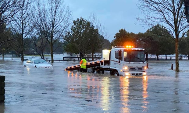
A powerful early winter storm is crawling up the southeast coast of Australia today, bringing abnormally cold and moist air into Victoria and New South Wales. A steady stream of heavy rain has been funneling into the Gippsland region of eastern Victoria since Wednesday. Rainfall totals there have exceeded 200 mm in many areas, leading to serious flooding. Rivers and creeks have risen swiftly overnight with several gauges at major flood levels, the highest in nearly a decade. These surging waters are flooding homes and businesses in many towns, leading to hurried evacuations. The State Emergency Service (SES) has fielded nearly 6,000 calls for assistance. Numerous roads are now closed, and officials are concerned that major arteries like the Princes Highway could be next. Most of the heaviest rainfall has already fallen, but runoff from smaller tributaries could cause significant flooding issues along the region’s bigger rivers in the coming days.
This is what residents in Traralgon are waking up to this morning. The Traralgon Creek is currently 4.33m and rising. Expected to exceed major flood level of 4.8m and peak at 5.3m this morning. @9NewsMelb pic.twitter.com/6dJ7uUl2IJ
— Mimi Becker (@MimiRoseBecker) June 9, 2021
Flood damage in Walhalla!#Victoria #melbourneweather #weather #flood #Australia #walhalla pic.twitter.com/GqzDGra191
— Joban Randhawa (@iJobanRandhawa) June 10, 2021
Winds have also been a widespread hazard late Wednesday into Thursday morning over central and eastern Victoria, including the Melbourne metro. Gusts in the city peaked in the 70-100 kph range, but surrounding higher elevations saw gusts as high as 125 kph. These high winds combined with soil weakened by the heavy rains have led to numerous downed trees and power lines. Hundreds of thousands are reported without power. Flooded roads will only delay repair and power restoration efforts. The story further north in the Dividing Ranges of eastern New South Wales is anomalous low-level snow. Parts of the capital district of Canberra saw unusual snow flurries with a dusting of accumulation on Wednesday. However, surrounding higher elevations are seeing much heavier totals, upwards of 50 cm by week’s end. The heavy snows combined with high winds are causing dangerous blizzard conditions with high drifts and near-zero visibilities. Lead photo courtesy Facebook user Melina Bath.
Best snow in almost six years blankets the Bathurst region overnight https://t.co/fP0QSHloxp
— Western Advocate (@WesternAdvocate) June 9, 2021
#melbourneweather #lilydale @3AW693 @RossAndRussel @abcmelbourne @9NewsMelb pic.twitter.com/YeL0nbY5ia
— Ben Rothberg (@b_rothberg) June 9, 2021
